
History and Master Plan
Airport History
In the late 1950's, preliminary planning for a County owned airport in St. Mary's County was begun. A survey was performed in 1966 that indicated a need for an airport which would accommodate medium sized twin engine aircraft. Many aircraft were known to be based in St. Mary's County on small, private strips and fields. The airport was to accommodate them as well as light industry in the County and to provide air service to NAS/NATC.
Three (3) sites were eventually selected for detailed study, and the present site was chosen as the most advantageous and feasible alternative. The original airport properties were acquired in August 1968 , construction of the St. Mary's County Airport was completed during 1969, and the Airport was in operation before the end of that year. The total project costs, which included land, engineering, administrative, and construction costs totaled $392,901.75. Federal financial participation by the Federal Aviation Agency, under the Federal Aid Airport Program (FAAP), was $150,100. Subsequently, a 10,000 foot aircraft maintenance, and storage hangar, with adjacent offices and public areas was constructed. The hangar facilities were completed by the end of 1975. The total hangar cost was $180,542.30. It wasn't until 1978 that the County received it's first grant monies from the FAA for the development of an Airport Master Plan.
Airport operations were conducted under a lease agreement between the County and Professional Flight Services, Inc. from the opening of the Airport through December 1976. From January 1977, through March, 1980, the Airport was leased for management and operations by Southern Maryland Aviation, Inc. In 1979, the Airport Master Plan was finally completed and demonstrated future needs for the Airport. The Airport was then leased to St. Mary's Aero Services, Inc. during the spring of 1980. An Airport Commission was soon established to manage the Airport in accordance with bylaws that were adopted on May 24, 1983. Airpark Sales and Services, Inc. was eventually designated as the Fixed Based Operator (FBO) in September 1987. In September 1988, the Airport Layout Plan (ALP) was updated and adopted. Following numerous infrastructure improvements, By August 1994, "Rules and Minimum Standards" were drafted and adopted by the Commissioners of St. Mary's County and are recorded at Deed Book 009 Pages 124-196. In 1997, with $1.8M of FAA eligible funding, the end of Runway 29 was extended from 3250' to 4150', the taxi-way was widened from 60-75' and over-layed to accommodate aircraft in excess of 12,500 pounds. A $3.1M terminal building was completed in the Spring of 2000 using MAA funding and the airport was designated as the Captain Walter Francis Duke Regional Airport at St. Mary's.
The Airport property now encompasses approximately 224.5 acres and was obtained in fee simple from Mr. and Mrs. Mervell Dean (138.24 acres), Mrs. G Claude Abell (15.48 acres), Mr. and Mrs. Paul R. Nimmerichter (33.10 acres), and Mr. and Mrs. Joseph Waldschmidt (35.72 acres). Of the total acreage, the 85.35 acre North Parcel, is dedicated to future development of an airport industrial or technology park. Current plans call for an extension of the runway to 5,350' and scheduled commuter air service.
Grant Funding Summary
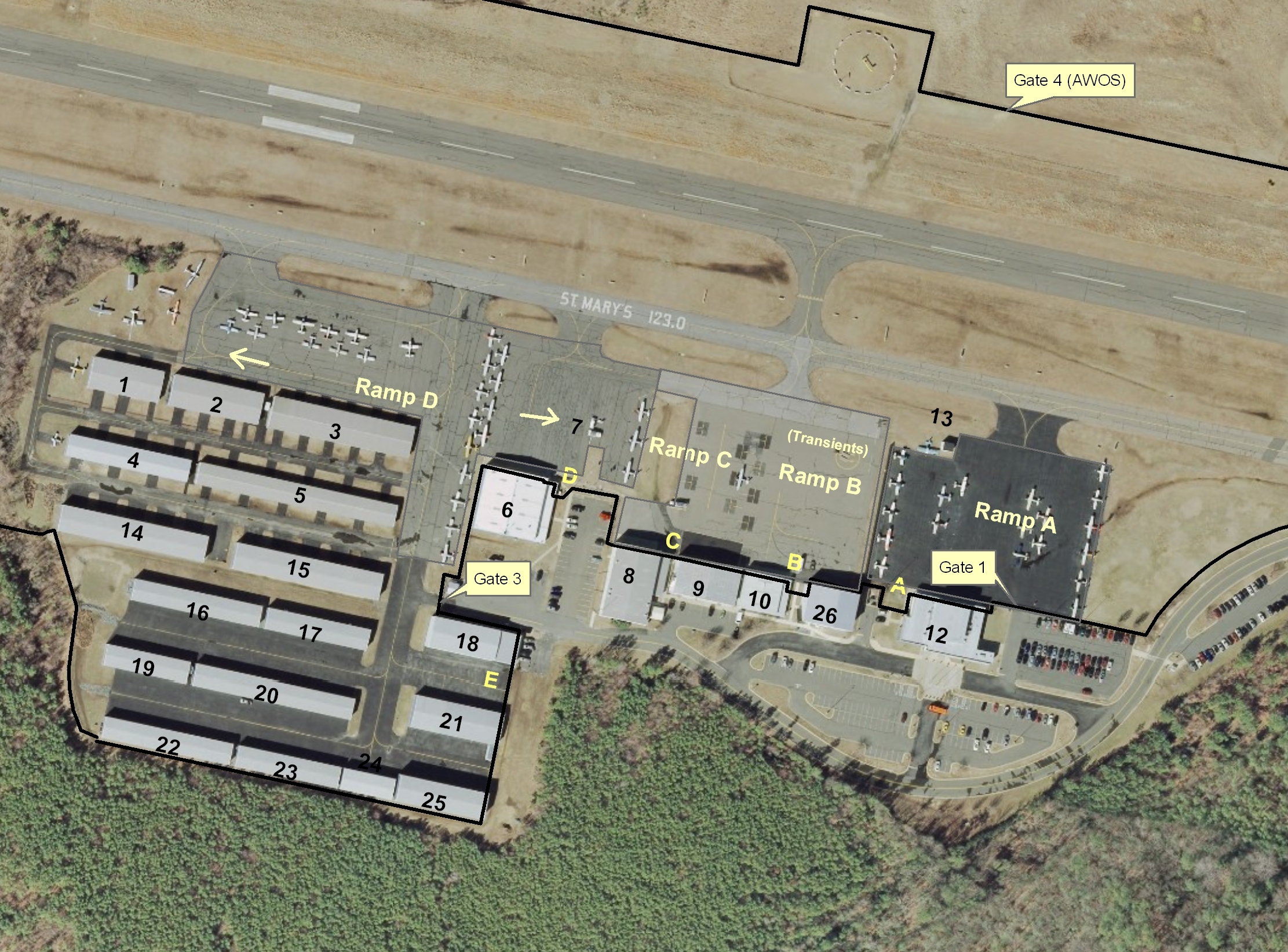
In 1978, the Airport received a federal grant for an Airport Master Plan. Since that time, St. Mary's County Airport has received both federal and state funding for numerous airport development and improvement projects. The Airport Layout Drawing (PDF). The list linked below provides a brief history of the numerous federal FAA and state MAA grants that have been awarded to St. Mary's County for implementation of the approved master plans and airport layout drawings. The Table includes dollar amounts, dates, and a brief description of each project. To date, thirty one (31) projects (Airport Grant Funding Project List (PDF)) in excess of $34.5 million have been granted to the expansion and upgrade of this facility.
Airport Master Plan
The Master Plan Update presents the results of data collection, forecasts, alternative analysis, and recommendations for the continued development of St. Mary's County Regional Airport. The previous Airport Master Plan was prepared in 1979 and Airport Layout Plan Updates were published in 1988 and 1993. Since that time, the region has experienced significant growth and the Airport has undergone numerous changes and improvements. In addition, the Airport is interested in developing the facilities to ultimately support commuter air service operations. The staging of development in the plan set will be tailored to meet the goals and objectives of the community for the airport over the next 20 years. The plan set will satisfy federal guidelines for airport development identified in the Federal Aviation Administration (FAA) Advisory Circular (AC) 150/5300-13 "Airport Design".
The current Master Plan Update will concentrate on assessing the existing conditions and future needs at the airport. This assessment begins with an inventory of the existing facilities, forecasts future aviation traffic demands, discusses the demand for future growth, and analyze facility and navigational aid requirements. Various development alternatives will be considered along with their potential effect environment. Cost estimates for recommended development are presented will also be presented in the Master Plan and include anticipated funding levels from federal, state, local, and private sources.
The current Airport Master Plan update (PDF) will concentrate on assessing the existing conditions and future needs at the airport.
The primary goals and objectives of the current Master Plan and Environmental Assessment (PDF) are to:
- Develop a Localizer approach (with approach lights) to Runway 11 to better accommodate aircraft traffic during periods of adverse weather.
- Evaluate feasibility of ILS approach.
- Lengthen and strengthen Runway 11-29 in preparation for commuter air service, commercial and other general aviation use.
- Determine the needed additional infrastructure to accommodate future commuter air service, commercial and other general aviation use.
- Recommend and develop a land acquisition program for the Airport to accommodate general aviation and commuter air service development for the 20-year planning period.
- Provide areas for additional general aviation apron and hangar (both T-hangar and conventional) development.
- Further refine orientation and layout for future development needs.
- Analyze existing and future obstructions to the FAR Part 77 surfaces.
Airport Compatible Land Use
The attached Airport Cooperative Research Program Report (PDF) discusses airport-compatible land-use requirements, the legal issues related to achieving airport compatible land use, and legal issues particular to eliminating hazardous obstructions to airspace. The report concludes by reviewing the major legal issues of concern in achieving airport-compatible land use. This report should be helpful to airport administrators, attorneys, board members, financial offers, community members in the vicinity of airports, realtors, and city and county zoning officials, In addition to the above, Chapter 43 of the St. Mary's County Comprehensive Zoning Ordinance (PDF) contains a detailed description of Compatible Use Zones and Airport Environs for development of airports, airfields and heliports. Please also refer to the Airport Airspace Exhibit (PDF) and Airport Zoning Exhibit (PDF).