
Traffic Analyses
Accident Data
Accident data is received annually from the SHA and is mapped / analyzed by the Engineering/Development Review Divisions as a part of the County Highway System maintenance effort. Specific incidents and areas of special concern are field evaluated immediately following the request and receipt of the Sheriff’s Motor Vehicle Accident Report which indicates probable cause. Field evaluation includes photographing the location, evaluating pavement conditions, verifying adequacy of approach signage, assessing obstructions, performing ball bank indicator reports on curves and recommending remedial action. A threshold rate of 2.41 accidents per million vehicle mile on a low volume road is considered “high” and is much higher than the average rate of 1.56 established for higher volume roads. A Speed Monitoring Program was developed in November 1998 utilizing existing traffic counting devices and will be utilized to respond to the nuisance complaints of citizens. The Program will assess the average and median speed of all vehicles, the number and percent of vehicles exceeding specified threshold speed limits and the 85th percentile speed. All of which will streamline the law enforcement and safety efforts within the effected communities. In 1999, the U.S. Department of Transportation explained that 61% of all fatal accidents in the U.S. occurs on rural roads even though rural roads account for only about 40 percent of all vehicle miles traveled each year. Most were the result of excessive speeding or inattention by motorists.
Traffic Counting
Traffic counts are performed by the County Highways Division and a traffic consultant to supplement the accident evaluation process, to verify the functional classification of the County’s roadways and to ensure the most current information is available to the development community. The frequency of accidents and the corresponding traffic volumes mathematically indicate if a segment (1/2 or ¼ mile length) is considered a High Accident Section. Depending on the potential for a repeat occurrence or the historical frequency, the area is signed and/or placed into the Capital Improvement Program for re-constructive improvements. Updated information is posted in the Road Data Index and is used by designers to perform adequate public facility reports, traffic impact studies and roadway design. In 1998, the Department initiated a solicitation and selection of an open-ended professional Transportation Planning and Traffic Engineering consultant to assist in these services.
Traffic Impact Studies
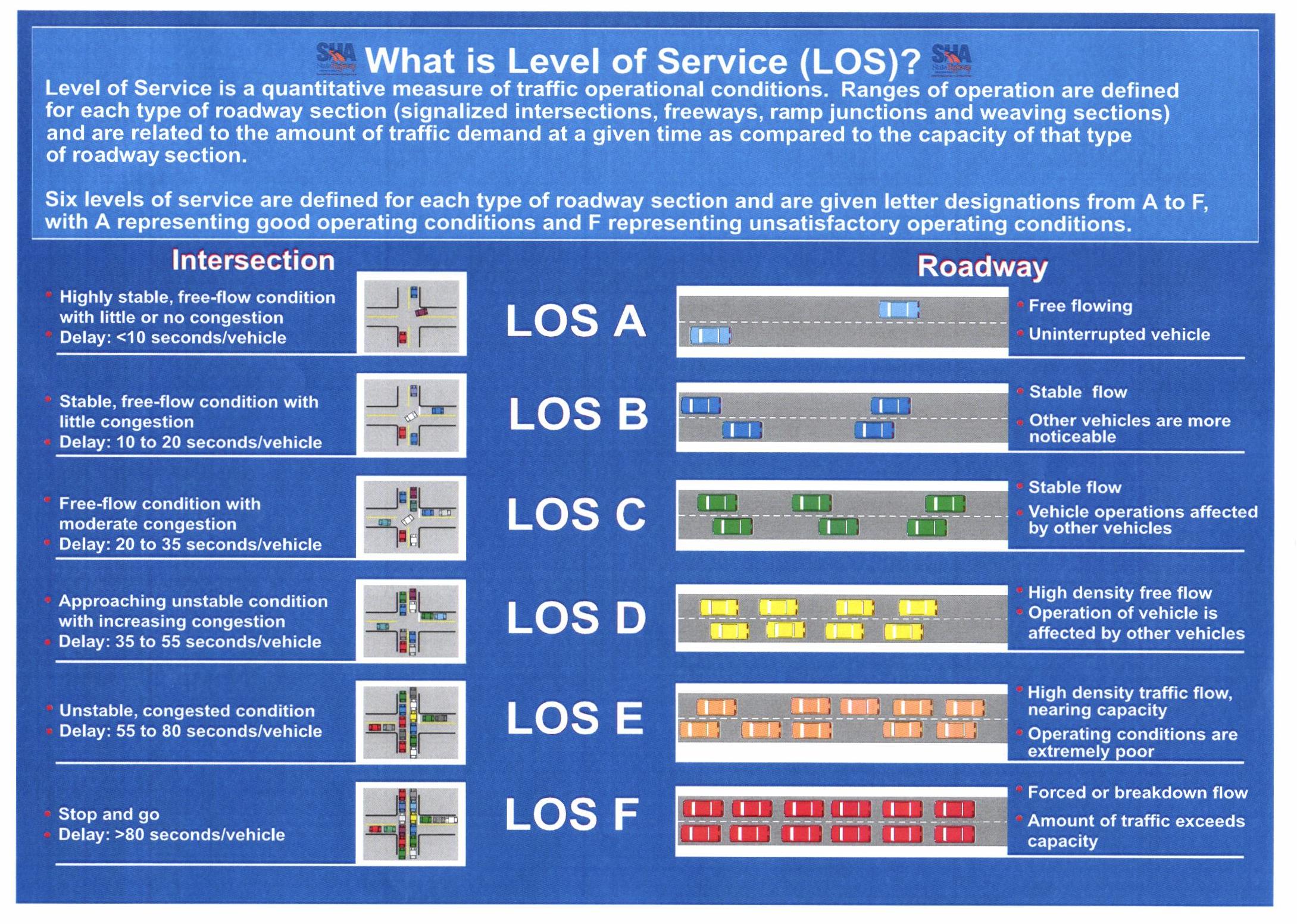
As a part of the development review process and before construction is permitted to begin on a new road, traffic signal, or turn lane, transportation officials want to see the impact that construction would have on local traffic and what sort of demands would come from it. A traffic impact study must be submitted in accordance with the requirements set forth in the Zoning Ordinance and usually includes an analysis of the level of service. A traffic impact analysis is a study which assesses the effects that a particular development’s traffic will have on the transportation network in the community. These studies vary in their range of detail and complexity depending on the type, size and location of the development. Traffic impact studies should accompany developments which have the potential to impact the transportation network. They are important in assisting public agencies in making land use decisions. These studies can be used to help evaluate whether the development is appropriate for a site and what type of transportation improvements may be necessary. Traffic impact studies help communities to:
- Forecast additional traffic associated with new development, based on accepted practices.
- Determine the improvements that are necessary to accommodate the new development.
- Assist communities in land use decision making.
- Assist in allocating scarce resources to areas which need improvements
- Identify potential problems with the proposed development which may influence the developer’s decision to pursue it.
- Allow the community to assess the impacts that a proposed development may have.
- Help to ensure safe and reasonable traffic conditions on streets after the development is complete.
- Reduce the negative impacts created by developments by helping to ensure that the transportation network can accommodate the development.
- Provide direction to community decision makers and developers of expected impacts.
- Protect the substantial community investment in the street system.
A traffic impact study will outline how much traffic exists during peak times, which roads vehicles utilize, and what adjustments or improvements need to be made to surrounding roadways. A traffic impact study is not necessary for every development. Those developments that are unlikely to generate significant traffic generally do not normally need a traffic impact assessment. However, even if the development does not generate the threshold level of trips, a traffic analysis may still be necessary under the following conditions: high traffic volumes on surrounding roads that my affect movement to and from the proposed development; lack of existing left turn lands on the adjacent roadway at the proposed access drive; inadequate sight distance at access points; the proximity of the proposed access points to other existing drives or intersections. When a traffic impact study is required, the applicant submits an analysis of traffic flow of the roads, highways, and intersections identified in the preliminary analysis based on the vehicle trip generation data submitted as part of the adequate public facilities review. Traffic impact studies are submitted to the Department of Public Works & Transportation and may be reviewed by an independent, qualified professional at the expense of the applicant.
Modernized Equipment
In July 1999, the Department upgraded its’ analysis software, counters and traffic classifiers. The new systems are comprised of TMWin/Janus software, a single button Beta Counter, and Delta III Classifier. We are now able to: give a listing of every speeding vehicle, by type and time of day; find volumes, speeds, axle classes and gaps of every vehicle for up to 30 days; count reliably at speeds down to 5 m.p.h.; measure speeds with a single road tube; simulate a radar gun and find the speed of only the vehicles in the free flow; give a true vehicle count and not just passenger car equivalents; classify vehicles using more than one classification scheme; and distinguish between two tailgating cars and a four-axle truck. These systems have a 30 day capacity, programmable intervals, variable start and stop dates/times settings and allow the operator to preview reports before printing. All units are equipped with a weatherproof housing, adjustable air sensors and a rechargeable battery.
Resolutions
Resolutions for the safe posting of roadways is routinely done as a part of the development review process and the acceptance of new roads into the County maintenance system (i.e. Stop, yield, speed limit and no parking signs). However, in the interest of public safety and the desire to eliminate hazardous conditions, the implementation of certain traffic control devices are necessary and include weight limit restrictions, temporary road/bridge closures, reduced speed limit signs and other warning, regulatory and informational signage. Each year, between 50-100 resolutions are presented to the Commissioners of St. Mary's County for signature authority.